Drone Tunnel Inspection: Benefits, Technologies, and Best Practices
In an era of aging transportation infrastructure and urban underground pipe networks, inspecting tunnel structures for safety has become a critical priority for highway, railway, and metro operators worldwide. Traditional tunnel inspection methods rely heavily on manual foot patrols, temporary scaffolding, or heavy elevated work platforms. These methods are not only time-consuming and expensive, but they also require frequent traffic closures and expose personnel to severe risks such as cave-ins, falling rocks, and high-altitude drops.
With the rapid advancement of Unmanned Aerial Vehicle (UAV) technology and autonomous navigation algorithms, drone tunnel inspection offers a modern, high-tech alternative for infrastructure maintenance.
How do drones execute tunnel inspections? What structural defects can they detect? What critical factors should you consider when selecting a tunnel inspection drone? Read on to find out.
Table of Contents
Why Use Drones for Tunnel Inspection?
The fundamental utility of drones in tunnel inspections does not lie in replacing human inspectors but rather in acting as a valuable resource in the management of modern underground infrastructure in a digital format. They help engineering teams collect accurate field data and maintain digital asset records that can be sustained into the future.
Improve Access to Hard-to-Reach Areas
Tunnel crown, haunches, areas over machinery, and cross-passages are frequently hard to examine from the surface level. Existing techniques usually involve building temporary platforms, aerial lift use, or sending additional personnel to reach such places.
In proper conditions, a drone may fly and make photos of such areas in the air, thus minimizing the number of temporary raised works.
Nevertheless, the ability of the aircraft to gain access to certain areas remains contingent upon tunnel cross-sectional size, obstacles, wind, dustiness, illumination, signal propagation, and collision prevention system of the drone.
Reduce Personnel Exposure to Inspection Hazards
Inspection of tunnels entails several risks such as the movement of vehicles, train movements, wet conditions, entry into enclosed spaces, and working at heights.
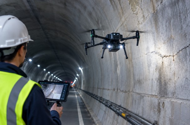
When used in proper working conditions, drones make it possible for operators to monitor the flight and gather information without having to enter any high-risk areas.
Despite the fact that using drones reduces risks of operation, there are still some risks involved when inspecting active tunnels. For instance, there is need for lane and track closure and permits as well as electrical, fire, and confined space safety procedures.
Improve Inspection Efficiency
The drones can gather information according to preset routes or strategies, where the repetitive process of gathering manual information and manual data recording will be automated.
An example of its application would be the autonomous collaborative air and ground tunnel inspection system developed by Hong Kong Productivity Council (HKPC) in 2025. Through the collaboration of drones, UGVs, AI imagery analysis, and positioning, it will thoroughly inspect different tunnel sections.
Data from the project made public by HKPC showed that the particular system had improved inspection speed by about 23 times and brought down the inspection cost by about 50% in comparison to traditional means. It is important to mention that the indicators discussed above are based on a particular project design and a particular system arrangement; therefore, generalization is not possible in this context.
This example shows that through the integration of drones with positioning, data processing, and inspection processes, automation can greatly increase efficiency in particular areas.
Create Repeatable Digital Inspection Records
In conventional inspection log formats, the logs comprise of paper-based forms, photographs taken in the field, and manually written comments. The lack of standardization on positional data, directional data, or chainage data makes tracing any changes in the structure over time extremely difficult.
Inspections conducted through drones connect images with timestamps, tunnels’ chainage or sections, and defect identification tags. Through positioning or mapping, any defect can be mapped into 3D models or coordinate systems.
With such systematic records, the creation of an asset maintenance log becomes possible as a basis for future inspections and structural health monitoring.
Applications of Drone Tunnel Inspection
Different types of tunnels vary significantly in structural design, environmental conditions, and inspection priorities. Therefore, drone deployment strategies must be tailored accordingly.
Road and Highway Tunnel Inspection
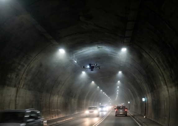
Road and highway tunnels require routine inspections of concrete linings, joints, lighting fixtures, ventilation systems, and auxiliary structures.
Drones can capture clear visual imagery across key zones:
- Concrete surfaces along tunnel crowns and haunches
- Lining joints and visible surface cracks
- Water seepage marks, concrete spalling, and surface anomalies
- External conditions of lighting fixtures, cable trays, and jet fans
After thorough assessments of traffic control and flight safety, drones can assist in inspecting elevated and hard-to-reach areas. For tasks requiring crack depth verification, internal void detection, or structural load capacity assessment, complementary non-destructive testing (NDT) methods should be applied.
Railway and Metro Tunnel Inspection
Inspections in the railways and metro tunnels include the inspection of concrete lining, trackside facilities, signaling equipment, power cable, mounting bracket, and structural assets.
Positioning and flight safety considerations are important since there are no GNSS/satellite signals available in such underground tunnels.
In 2025, the MTR Corporation of Hong Kong carried out tests for the use of drones for inspections in rail tunnels. As reported by MTR in the press, it used to take 30 minutes to complete the inspection of 1-kilometer tunnel by hand; however, the drone completed this job in less than 10 minutes.
That indicates that for specific operations, the inspection process could theoretically be reduced to less than a third. But this standard is not necessarily applicable to all railroad tunnels, neither does it mean that drones can independently perform all kinds of rail inspections.
For railroad purposes, in addition to the points considered above, it will be necessary to take into account the schedule of train runs, power isolation of tracks, communication management, drop prevention of equipment, and obtaining operator approval.
Utility Tunnel Inspection
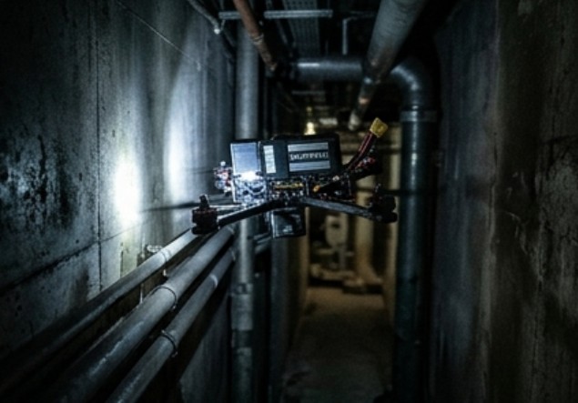
Utility tunnels and underground utility corridors house water supply pipelines, power cables, communication lines, drainage infrastructure, and ventilation networks.
Drones may examine visible pipe surfaces, joints, bracketry, leakage marks, and local equipment status, especially over extended distances or places that cannot be accessed because of obstacles within the tunnel.
But in situations where there is the presence of high-voltage electricity equipment or the possible presence of flammable and explosive gases, safety measures need to be taken into consideration.
Water and Hydropower Tunnel Inspection
These water conveyance tunnels, stormwater tunnels, and hydro power tunnels have tough conditions that include humidity, wetness, silt, poor visibility, and high signal degradation.
In ideal conditions, the use of UAVs can be employed in capturing visual surface imagery to facilitate inspection of the linings, construction joints, and local appurtenances.
Before settling on the equipment that will be used in these conditions, some of the factors to take into consideration include waterproofing, corrosion protection, lighting capabilities, recovery plans, and flight stability in high humidity conditions. When there is water flowing in the tunnels and tight turns, flight stability and emergency recovery plans should be taken into account.
Tunnel Construction and Progress Monitoring
In the course of tunneling work, the drone is used in observing the progress of tunnel excavation, the quality of the surface linings, the fixtures inside, and other construction deficiencies observable.
Through the implementation of photogrammetry or 3D LiDAR scanning, the gathered data can be overlaid on the BIM/CAD design models for assisting the engineering practitioners in detecting geometric differences and inconsistencies within the structures in an earlier phase.
The implementation of automated inspection and evaluation of cross-passages in double tunnels by utilizing drones, photogrammetry, and point cloud was examined in research performed in 2025 and published in Automation in Construction journal.
Such research is characterized by the fact that it focuses on developing drone technology not only into aerial image capturing but also into digitization process through positioning and 3D imaging.
What Can a Tunnel Inspection Drone Detect?
A tunnel inspection drone can identify a wide range of visible structural anomalies. However, the reliability of the results depends on sensor selection, standoff distance, lighting, image resolution, data processing algorithms, and field conditions.
Visible Cracks and Concrete Spalling
High-definition optical cameras can record surface cracks, spalling, delamination, and mechanical damage, providing clear visual evidence for structural engineers.
Keep in mind that crack width in a photograph does not automatically equal actual crack width. Standoff distance, camera angle, lens distortion, lighting uniformity, and image compression all affect measurements. If precise crack width or depth data is required, validated photogrammetric calibration procedures and manual field verification should be used.
Water Leakage and Surface Deterioration
Seepage spots, wet areas, efflorescence (white salts), flaking surfaces, and chemical corrosion serve as early indicators for the maintenance crew.
While the picture taken from above can help in locating the exact spot where these damages happen, nevertheless, it does not tell us how much water is leaking or how much pressure the pipe contains or the extent of subsurface damage.
Tunnel Geometry and Clearance Changes
Equipped with suitable mapping sensors, positioning frameworks, and processing software, drones can help generate 3D mesh models or point clouds to monitor tunnel cross-sections, surface profiles, and clearance changes.
However, raw RGB photos do not automatically yield survey-grade measurements. If a project requires verifying clearance envelopes or structural deformation, ensure the system’s spatial accuracy, calibration protocol, coordinate reference system, and validation procedures satisfy civil engineering standards.
Lighting, Cables, and Ventilation Equipment
Drones can be used to inspect any overhead lighting, jet fan housing, cable tray, conduit, and auxiliary equipment.
These inspections are meant to detect any external damage, loose mounting, missing parts, and physical misalignment. Internal breakdowns in terms of mechanics and electricity have to go through other methods of inspection.
Key Technologies for Drone Tunnel Inspection
Unlike the open airspace outside, there are no GPS/GNSS signals in tunnels and some other difficulties, such as low lighting, constrained spaces, repeated wall patterns, and poor wireless signals.
The essential technology considerations when choosing a tunnel drone are:
High-Resolution Cameras and Auxiliary Lighting
Camera pixel count is only one factor in inspection image quality. Standoff distance, focal length, exposure settings, motion blur, light distribution, and compression ratios are equally important.
For crack and spalling detection, select camera optics based on the minimum target defect size, operating distance, and required spatial resolution. Auxiliary lighting systems should deliver uniform illumination without creating harsh glare, deep shadows, or overexposed hot spots on reflective surfaces.
Before purchasing, ask vendors for real-world test images captured at actual operating distances rather than relying solely on nominal sensor specs.
LiDAR and 3D Mapping
The term LiDAR refers to Light Detection and Ranging, where reflections from laser beams are used to measure accurate spatial distances through point clouds created in 3D space.
It is clear that unlike 2D images, 3D point clouds have actual geometry, making them ideal for use in tunnel mapping, volume calculation, and clearance determination.
System Accuracy Factors include sensor specification, scan range, reflectivity of the object, movement of the platform, registration of the point clouds, and control points. If an engineering survey is being conducted, it is necessary to check whether the accuracy of the system has been certified.
SLAM and GNSS-Denied Navigation
SLAM (Simultaneous Localization and Mapping) enables a drone to estimate its position while incrementally building a map of its surroundings using onboard sensors.
In GPS-denied tunnels, visual SLAM, LiDAR SLAM, or Visual-Inertial Odometry (VIO) allow drones to achieve stable hovering, relative positioning, and safe navigation.
Even with SLAM capability, the drone is not guaranteed to perform flawlessly in all tunnel environments due to featureless walls, airborne particles, heavy smoke, low lighting conditions, rapid movements, drifting after covering large distances, and dynamic obstacles.
In cases where precise geographic referencing is required, artificial targets should be incorporated.
Obstacle Avoidance and Collision Protection
Utility pipes overhead, cable troughs, jet fans, structural ribs, and any temporary equipment in construction are potential collision hazards in tunnels.
Visual, depth, LiDAR, or ultrasonic sensors aid in situational awareness of the environment for the aircraft. But these depend on the FOV, reflectivity of targets, illumination, and computational delay of the sensors.
While flying in cramped quarters, emphasize on having a small airframe size, complete safety cage/guards, hovering capabilities, low-speed flight capability, and safe flight termination maneuvers.
AI-Assisted Defect Detection
The algorithms of AI technology are capable of classifying, locating, and tagging any structural defects from the vast amount of imagery, thus creating automatic inspection reports.
Practical examples like the joint tunnel inspection efforts carried out in Hong Kong prove the benefits of combining the imaging and positioning of drones with AI technology.
The outputs generated by AI technology need to be validated through actual field information. The important structural defects always have to be verified by humans.
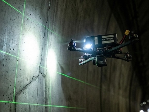
Standard Operating Procedure (SOP) for Drone Tunnel Inspection
To ensure operational safety, data integrity, and asset traceability, engineering teams should implement a standardized inspection workflow:
Mission Planning & Site Reconnaissance
Define inspection goals, coverage areas, and data deliverables. Conduct a pre-flight assessment of tunnel dimensions, lighting, obstacles, ambient airflow, and wireless signal conditions. Evaluate indoor positioning (e.g., SLAM) suitability and perform a formal risk assessment.
Equipment Inspection & Flight Verification
Inspect the airframe, propulsion systems, batteries, optical sensors, auxiliary lights, and navigation payloads. Conduct a short test flight on-site to verify flight stability, positioning accuracy, imagery clear-ness, and emergency fail-safe procedures before full deployment.
Data Acquisition & Aerial Inspection
Execute the flight path to inspect the tunnel crown, side walls, lining joints, and overhead assets, capturing systematic imagery or 3D point cloud data. Flag and record real-time coordinates/chainage for suspect cracks, spalling, or moisture leaks.
Data Analytics & Defect Verification
Process raw data into stitched orthomosaics, 3D mesh models, or AI-tagged defect maps. Ensure structural engineers review major anomalies and cross-verify critical findings with traditional NDT tools if structural integrity is questioned.
Report Generation & Digital Archiving
Compile a detailed inspection report detailing surveyed sections, equipment parameters, defect coordinates, visual evidence, and recommended maintenance actions. Archive standardized raw data to enable long-term structural health tracking across multi-year inspection cycles.
How to Choose the Right Tunnel Inspection Drone
Selecting the right tunnel inspection drone requires matching equipment capability to jobsite requirements rather than focusing solely on flight time, top speed, or payload capacity.
Evaluate Tunnel Dimensions & Environmental Conditions
Select airframe dimensions and propulsion stability based on tunnel length, width, overhead clearance, dust levels, ambient airflow, and humidity. For tight cross-passages, focus on compact airframe profiles, precise hovering, and full collision-protection cages.
Assess Indoor Navigation & Positioning Specs
Since GNSS signals are unavailable underground, verify that the drone supports proven GPS-denied navigation tech (e.g., LiDAR/Visual SLAM) to ensure flight stability and spatial tagging of inspection data.
Choose Appropriate Sensor Payloads
Match sensors to inspection goals. High-resolution RGB cameras with high-CRI auxiliary lighting excel at surface crack and spalling detection, while LiDAR payloads are essential for 3D geometric modeling and cross-sectional profiling.
Review Battery Endurance & Communications
Analysis of actual flight duration based on full load weight, signal transmission stability, storage capacity, and rescue options needs to be done. This is crucial in long tunnels and in conditions of high signal attenuation.
Prioritize Operational Safety & Reliability
Examine collision avoidance sensors, physical protective shielding, maintenance cycles, and fail-safe modes. If flammable or explosive gases are present, confirm the aircraft meets applicable HazLoc/explosion-proof safety ratings.
VastArrive Drone for Tunnel Inspection
There are high requirements for the stability of the device, the endurance of its battery, and the flexibility of the load. As an established brand that strives to bring new ideas to industrial drones, VastArrive offers reliable industrial drone systems and inspection solutions for infrastructure managers, engineering companies, and transportation agencies around the world.
VA-FPVD13 Industrial Underground & Tunnel Inspection Drone
The VastArrive VA-FPVD13 is engineered specifically for long-distance tunnels, underground utility corridors, and culverts:
13-Inch 3K T300 Full Carbon Fiber Frame & Impact-Resistant Design:
Featuring a 593mm wheelbase and high-strength full carbon fiber construction, the VA-FPVD13 combines structural durability with agile maneuverability to navigate narrow tunnel crowns, utility cross-passages, and tight equipment gaps while resisting turbulent underground drafts.
4218 360KV High-Torque Motors & 25–35 Minute Long Flight Endurance:
Utilizing an 80A Electronic Speed Controller (ESC) and 8S 16000mAh high voltage battery pack, the drone allows up to 30 minutes of uninterrupted hovering and cruising time. This allows for multi-kilometer long flights without the need to replace the battery mid-flight.
1800TVL Low-Light Night-Vision FPV Camera:
It is specially made for dark underground areas, combining an auxiliary lighting system with a very good CRI along with a powerful 3W video transmitter that transfers high-definition images of small cracks, water infiltration, and concrete spalling to ground staff.
Exceptional Reliability and Cost Efficiency:
With excellent payload carrying capacity and endurance, the cost per unit is from $780 to $975, which greatly reduces costs and risks associated with hazardous underground surveys.
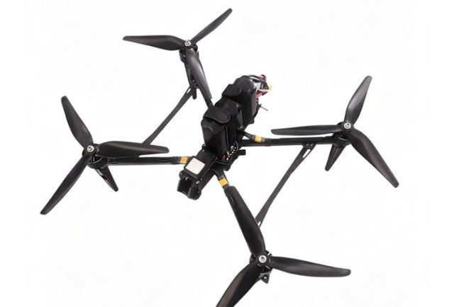
Besides the VA-FPVD13, there are other products from VastArrive for the purpose of high-altitude bridge inspections, pipeline survey, firefighting, and agricultural sprays.
Conclusion
Drone technology in combination with the artificial intelligence defect analysis process is transforming the field of inspection and maintenance of tunnel systems as well as other underground infrastructures. Regardless of whether you are looking at making it safer for the inspector or reducing the costs of shutting down traffic, industrial drones are now a must-have part of modern day engineering.
Ready to upgrade your infrastructure inspection capabilities?
Contact the VastArrive expert engineering team today to receive tailored drone recommendations and custom solution proposals for your tunnel inspection projects!