
Drone Soil Analysis: How UAVs Help Crop and Soil Health?
In the wave of modern precision agriculture, drone soil analysis is emerging as one of the most eye-catching changemakers in the agrotech sector.
The eras of “farming at the mercy of the weather” and “blind fertilization” in traditional agriculture are fading away. However, many growers and agricultural consultants still face immense challenges when managing hundreds of hectares of land: traditional manual soil sampling is not only time-consuming and labor-intensive, but its “point-based” sampling approach easily leaves blind spots.
How can we grasp the health status of an entire field quickly and comprehensively without disturbing the soil? The answer lies in the sky. This article takes an in-depth look at how drone soil analysis works, its core advantages, and how to leverage this technology for digital farmland management to reduce costs and increase efficiency.
Table of Contents
What is Drone Soil Analysis?
Drone soil analysis refers to the process of monitoring, collecting, and analyzing farmland soil data using drones equipped with various sensors and imaging devices.
Traditional soil testing typically relies on manual sampling and laboratory testing. While accurate, this method offers limited coverage and takes a long time. Drones, on the other hand, can scout large areas of farmland in a short period and generate detailed soil health maps, providing real-time data support for agricultural management.
Through drone soil analysis, farmers can obtain:
- Soil moisture distribution
- Soil nutrient status
- Soil temperature variations
- Soil compaction zones
- Drainage and waterlogging conditions
- Soil erosion risk assessments
How Do Drones Analyze Soil?
Many people mistakenly believe that drones just take ordinary photos from high altitudes. In fact, equipment used for agricultural drone soil mapping is packed with highly sophisticated sensors that utilize spectrum data invisible to the naked eye to “diagnose” the land.
Its core technology primarily relies on the following dimensions:
1. Multispectral & Hyperspectral Imagery
Soil has different reflectances for different wavelengths of light (such as visible light, near-infrared [NIR], and red edge).
Moisture-rich soil absorbs more near-infrared light.
Fertile soil with high organic matter content appears darker and exhibits specific spectral reflectance characteristics.
Multispectral cameras quantify the physical properties of topsoil precisely by capturing these subtle spectral changes.
2. Thermal Imaging
Thermal sensors detect the surface temperature of the soil. Temperature changes in the soil have a lot to do with the moisture level, the drier the soil, the faster it gets heated and cooled, and vice versa. Using thermal images, drones can help track water loss and waterlogging on the farm.
3. 3D Topography & Erosion Modeling
Utilizing RTK high-precision positioning and orthophotography, drones can generate centimeter-level Digital Surface Models (DSM). This allows growers to see terrain fluctuations, slopes, and rainwater runoff paths at a glance, effectively predicting and preventing soil erosion.
Core Advantages of Drone Soil Mapping
For large-scale crop producers, environmental consultants, or agricultural service providers, introducing drone technology is by no means just a “parlor trick”, it is an investment that translates directly into financial returns:
Variable Rate Application (VRA) to Drastically Lower Input Costs
Traditional “one-size-fits-all” fertilization is highly wasteful and can cause fertilizer damage, leading to reduced yields in certain areas. Soil organic matter and nutrient distribution maps generated by drones can interface with the auto-steering systems of modern tractors to implement Variable Rate Application. Apply fertilizer only where it is lacking and skip where it isn’t, this alone can save growers a fortune on fertilizer expenses.
Precision Irrigation for Efficient Use of Water Resources
With help from drone-based soil moisture detection and thermal cameras, it is evident where the soil is “drought stressed” and where there is an issue with drainage. Optimization of irrigation processes will enable crops to be harvested while saving water.
Proactive Prevention of Disasters to Ensure Good Crop Yield
Doing soil analysis using drones before planting will make it possible to identify problems such as soil compaction, salinization, or erosion. Thus, it will become possible to enhance the quality of the soil before planting seeds.
Typical Application Scenarios of Drone Soil Analysis
Monitoring Soil Moisture
The conventional fixed sensors have a limited range of detection; thus, it is hard to capture the moisture differences in small areas. Drones, fitted with infrared and multispectral imaging, can quickly map out wide expanses of farmland and detect severe water stress, over-irrigation, and poor drainage using changes in thermal radiation from the surface.
This moisture information can be directly integrated into smart irrigation systems to attain “irrigation on demand” and avoid root rot.
Soil Nutrient Analysis
Blind fertilization drives up production costs and causes soil pollution. By capturing specific spectral bands, drones can qualitatively and quantitatively analyze the distribution of the three primary macronutrients: Nitrogen (N), Phosphorus (P), and Potassium (K) in the soil and early-stage crops.
The system instantly flags and marks abnormal spectral areas caused by nutrient deficiencies, generating a “nutrient prescription map” to guide modern machinery in precise variable-rate fertilization.
Soil Compaction Detection
Heavy equipment used for farming purposes often causes soils to become compacted, greatly inhibiting root growth of crops, water infiltration, and oxygen diffusion.
Drones are able to identify minute elevation changes or signs of water logging using centimeter-accurate DSMs and thermal cameras. This allows management to locate compacted zones precisely and perform deep ripping in a timely manner to restore soil water retention and aeration.
Soil Erosion Monitoring
For hillside farming and large farms, topsoil erosion caused by heavy rains is an ecological and economic disaster. Regular drone patrols can build high-precision 3D terrain models to dynamically track soil erosion marks and assess local risks.
Growers can quickly lock onto loose slopes and expanding gullies before and after the rainy season, allowing them to terrace slopes or plant cover crops in time to lock in soil fertility.
Traditional Sampling vs. Drone Solid Analysis
To more intuitively understand its business value, let’s take a side-by-side look at how traditional human methods vs drone technology:
| Comparison Dimension | Traditional Manual Soil Sampling | Drone Soil Analysis |
| Operational Efficiency | Extremely low (digging, labeling, and lab testing takes days or weeks) | Extremely high (hundreds of acres can be covered within 1 hour) |
| Data Coverage | Discrete point data; easily misses “abnormal zones” in between | 100% comprehensive coverage, providing continuous gridded maps |
| Crop Disruption | Tramples fields during sampling; destructive | Zero-contact, non-destructive, and eco-friendly |
| Timeliness | Lagging reports; easily misses the optimal fertilization/irrigation window | Real-time or near-real-time data processing for instant production guidance |
| Deep Chemical Analysis | Excellent (accurately tests N-P-K levels and pH values) | Limited (primarily detects surface and physical properties; needs to be paired with traditional sampling) |
Expert Tip: Drone soil analysis does not completely replace laboratory testing. Its best role is as a “navigator”, using drone maps to find anomalous zones and then conducting precise, targeted sampling, which can save up to 80% of blind sampling costs.
4 Standard Steps to Implement Drone Soil Analysis
In order to gain valuable information about agriculture through the process, a scientific procedure should be followed:
Step 1. Flight Planning
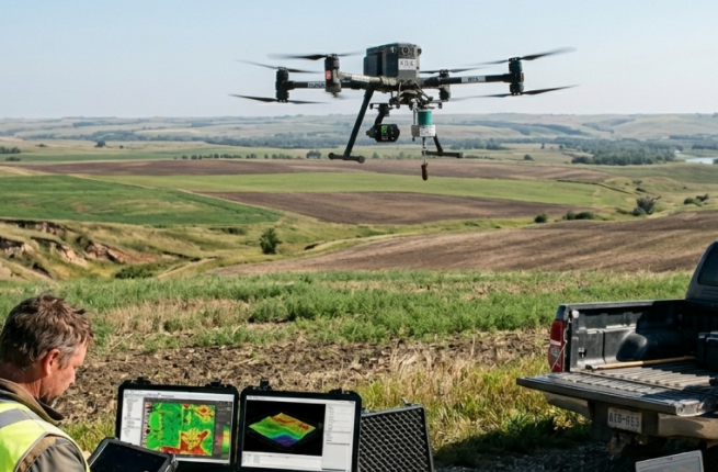
The boundaries of the farmland will be set in the flight planning application (such as DroneDeploy, Pix4D, etc.). Flight altitude and the overlap ratio will need to be determined considering the nature of the terrain (an overlap ratio of over 75 percent is advisable).
Step 2. Data Collection (Aerial Operations)
Drones equipped with multispectral or thermal cameras automatically execute the flight mission. It is recommended to fly during clear, stable lighting periods around noon to reduce spectral errors caused by cloud cover and shadows.
Step 3. Data Processing & Stitching (Software Modeling):
Upload the hundreds or thousands of photos captured by the drone into mapping software to stitch and generate high-resolution orthomosaics as well as specific soil spectral index maps.
Step 4. Ground Truthing (Field Calibration):
Head to the “low-index (abnormal) zones” flagged on the drone map with a GPS device to conduct targeted ground testing and calibration, ultimately formulating the perfect fertilization and soil amendment plan.
Conclusion: Start Your Digital Agriculture Journey
Drone soil analysis is more than just an efficient mapping tool, it is the technological foundation for modern farms to achieve precision management and sustainable development. By transforming spectral data from the sky into commercial decisions on the ground, you will not only see lower operating costs but also more rewarding crop yields.
Ready to upgrade your agricultural management? If you want to learn more about agricultural drone equipment selection or need professional digital farmland mapping services, feel free to contact VastArrive. We will provide you with tailor-made smart agriculture solutions.
FAQs about Soil and Field Analysis Drones
Q1: Can drones directly measure soil pH?
A: Current technology cannot directly “read” exact soil pH values through spectral cameras. However, drones can indirectly infer potential strong acidity or alkalinity issues by analyzing weed types or spectral performance of stunted early crop growth, guiding you to those specific spots for physical testing.
Q2: What kind of drone is best suited for soil analysis?
A: Consumer-grade photography drones are not up to the task. You need professional models that support RTK high-precision positioning and can carry multispectral cameras (such as the VastArrive B100P, AC200C, AC200D, etc.).
Q3: When is the best time to perform drone soil analysis?
A: Before planting (bare soil period) and during early crop emergence are the optimal windows. Before planting, there is no vegetation cover, allowing the drone to capture topsoil spectral and moisture data with extreme precision; during early emergence, soil fertility unevenness can be backward-inferred through crop growth status.